Sunday, October 23, 2011

Red Rock Canyon National Conservation Area, NV, USA

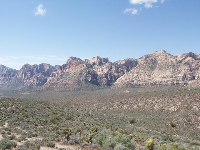
    I recently had the pleasure of visiting Red Rock Canyon while I was in Las Vegas, Nevada.  I had always wanted to see the desert in person , so this was my first real desert experience.  It was definitely not disappointing.  All the elements I expected were there: cacti, dusty hard ground, big mountains in the distance, and lots of sunshine.  

   I did just a short hike from one of the many different parking lots throughout the park.  The information packet they give you at the entrance has a comprehensive map and list explaining all the trails.  Take heed to the difficulty levels, there are hard trails and easy trails.  If you chose to do a long hard trail, remember this is the desert and you need to pack the appropriate amount of water.  For an easier option, there are places to park and have a picnic and take a stroll.  There's something for everyone.  


The rocks were very red!  The formation above is actually a lot bigger in person than it looks.  We saw people up there and they looked like little ants.


The road that loops through the park is awesome just for the ride.


The dust, the yucca, and the vista.


Me and the mountains that divide Nevada and California.


Pretty Mountains.  When we got closer to these mountains, we also saw tiny climbers half way up.  So there are plenty of mountains to climb for you mountaineers.


Speeding past red rocks. :o)


For more information about visiting:

Tuesday, October 11, 2011

Ace Adventure Resort - Hiking Trail

I recently visited the New River Gorge area in West Virginia.  Some friends and I visited the ACE Adventure Resort, which is near Thurmond, WV.  This resort has everything!  You can go white water rafting on the Gauley or the New River, kayaking, horseback riding, hiking, biking, mountain climbing, mud obstacle course, and climbing tower.  We've been here a couple times and we always have a blast.
When I visited this time, I was determined to go hiking.  When I had been in the past for white water rafting, all I did was party at the cabin when we weren't rafting or playing the lake.  So I got a trail map from the staff at Ace and it looked like an easy trail to the New River that would connect to the national park trail that ran along side the river.

The beginning of the trail started out nicely.  One of the first things you do is cross this cute little brook flowing over the path.  The trail continues down hill along the side of the mountain.  As we continued to walk down hill we got closer and closer to a creek running parallel at the bottom of the hillside we were on.  There were lots of spider webs across the path, making me think this wasn't a high traffic trail.  The trail was not blazed very well either, but it was obvious to keep going straight.  
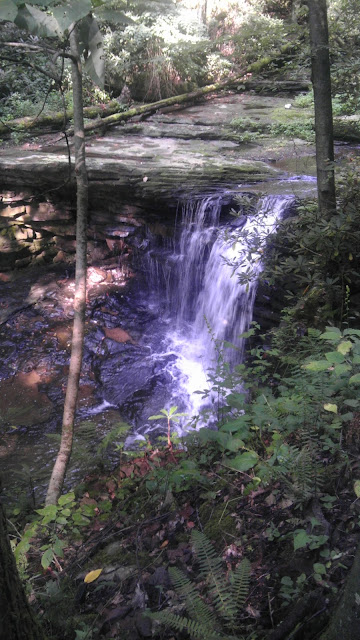
 Getting close to the creek was a highlight.  The creek had one waterfall after another, making beautiful sounds and presenting great photo opportunities.  However, we had been walking for what felt like an hour and it didn't seem clear that we were getting close to the New River.  I was also not excited about walking uphill the entire way back from where we just came.  So my friend and I decided to turn back before even reaching the New River.  I know!  Big disappointment, but my companion was not an enthusiast for hiking, so I figured I would torture her no longer.
Back up the mountain we were able to go back to playing in the activity lake, which can keep me occupied for hours! I probably went down that slide 10 times.  Notice in the picture there's a girl hanging from the zip line in the center towards the right.  Warning for the zip line: when you hit the water it will drag your bottom off if you're wearing a two piece!

Here's their website for more information: http://www.aceraft.com/


By the way, the visitor center for the New River Gorge National Park is a beautiful facility and worth stopping at.  The rangers are also very helpful and easy to talk to.  You can tell they love their jobs!

For more information about the New River: http://www.nps.gov/neri


Lake Churchill


Lake Churchill is a small lake, but a beautiful walk.  The paved trail that circles the lake is only a mile and a half long.  It's the perfect place for an after dinner stroll.  It's a favorite among locals.


The lake side path also connects to the Black Hill Regional Park trail as well, making it a nice extension if you're already walking on that trail.  Just across the street from Lake Churchill is Little Seneca Lake, which is actually a very large lake despite the name and it's part of Black Hill Regional Park.


Cozy spot to sit overlooking the lake.

 
Lake Churchill is the perfect place to catch the changing leaves of autumn reflecting off the glassy water.  As I walked around this lake recently I could see the beginning of the colors coming through and I know it will only get better in the next couple days.  Fall can pass by quick so don't miss it!


Here's the website for more information about Lake Churchill: http://lakechurchill.com/

Tuesday, October 4, 2011

Seneca Creek at Berryville Road

Just wanted to share some video I took of Seneca Creek when it was extra swollen from a week of rain.

Monday, October 3, 2011

C&O Canal: Riley's Lock

Riley's Lock is one of the many places along the C&O Canal that you can park to access the towpath.  The C&O Canal is a National Park with 134 miles of trail which starts in Washington DC and follows the Potomac River west.  
Aqueduct at Riley's Lock
 Riley's Lock has a small boat ramp so recreational boaters and fishers can access the Potomac River.  The ramp is on Seneca Creek, giving boats a gentle start before they enter the fast currents of the Potomac.  These pictures were taken when the creek and river were both very swollen from a week of non-stop rain.
Side wall of the Aqueduct

Riley's Lock House

View of Seneca Creek from the Aqueduct

View of swollen rapids on the Potomac River from C&O Canal towpath

Swollen Potomac waterfall near Violette's Lock

Brave kayaker

Violette's Lock, just south of Riley's Lock

Paddle Boarders enjoying the peaceful C&O canal

Potomac River, overflowing it's bank all the way to the retaining wall.

Potomac River, You can see how high the water is.  Poor bushes..

Lovely C&O Canal

Reflective waters of the C&O Canal

Towpath along the C&O Canal

Seashells so far from the sea!


For more information on visiting the C&O Canal, visit: http://www.nps.gov/choh

White Rock at Sugarloaf

I recently hiked the 5 mile blue trail at Sugarloaf Mountain in Maryland.  I took this awesome video of some eagles soaring at the White Rock overlook.  This overlook is about 3 miles from the west parking lot and totally worth the hike.  Below are some pictures I took along the way...
View along the beginning of the blue trail

McCormick Overlook

Rocks

Man-made rock formation at one of the lesser summits along the blue trail
Colorful Turtle hanging out in the middle of the trail.  Watch Your Step!

White Rock

White Rock

Me and my view at White Rock

White Rock, looking towards Frederick, MD

Eagles

Historic military fort near west end parking lot

View of Virginia from historic military